
WHEN? Sunday · October 12
WHERE? Perdido Key, Florida · find us on the map
WHAT? Gulf Islands National Seashore
Today's visit to Perdido Key was inspired by last Spring's scenic beach drive with our friend Steve. Johnson Beach's white sand and deep blue skies hadn't changed, and lots of healthy sea oats still waved in the breeze, but the beachfront looked noticeably different. We learned from park brochures that this wasn't our imagination, since tropical storms and hurricanes are always at work changing the shape of these beaches and barrier islands.
Image courtesy of flickr member christie210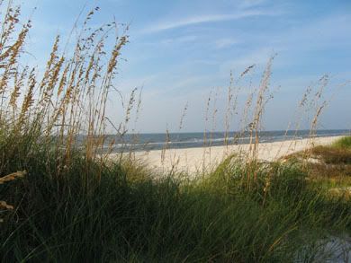
For current images, visit the Perdido Key BeachCam
Before leaving Johnson Beach, we picked up several park brochures and learned that this is one of many locations in Gulf Islands National Seashore. Instead of being a single block of land, it is a mosaic which includes 12 separate units that stretch from Cat Island in Mississippi, to the eastern tip of Santa Rosa Island, Florida, and includes some parcels on the mainlands of Mississippi and Florida.
- The Mississippi District includes:
- · Ship Island
- · Fort Massachusetts
- · Horn Island
- · Petit Bois Island
- · Davis Bayou
- The Florida District includes:
- · Perdido Key
- · Fort Barrancas
- · Fort Pickens
- · Naval Live Oaks
- · Okaloosa
click on map to enlarge

More:
- The beach we visited today was named in memory of local Korean war hero Rosamond Johnson.
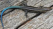
- Area wildlife in the seashore's sand dune habitat includes the five lined skink and the endangered Perdido Key Beach Mouse.

- In 1969, Hurricane Camille split Ship Island in two. Also, Hurricane Ivan damaged the buildings and changed the landscape of Perdido Key in 2004. The National Park Service webpage has some interesting info about the effects of hurricanes on the Gulf Islands National Seashore.
No comments:
Post a Comment